(Image from https://gripped.com/routes/howe-sound-crest-trail/)
This trail is a classic Vancouver trail that explores many of the local mountain peaks! I have been wanting to do this hike for ages, and am working with friends to make this trip a reality. To help us with planning, I’m going to add all the necessary info here into this post, and once I hike it I will come back and update this post with all my pictures and extra thoughts/opinions.
This trail is typically rated as “Very Difficult”, and requires hikers to be somewhat experienced, as well as having lots of time to complete the full trail. The trail is a total of 29km, with just over 1800m of up-and-down elevation gain. For the purpose of this post I am going to plan out the trip in a day-to-day itinerary, so if we are to hike it in the late Spring we have a set plan already.
Things to note: Best to do this hike if the weather is going to be completely dry, and has been for a day or two beforehand as well. There are segments that are slippery otherwise, and make the hike far more technical. This hike also has some epic but intense heights, so if you are afraid of heights, watch a few videos on the tricky segments of the trail to be aware of what to expect. From everyone I have talked to, and reviews I have read: Hiking Poles are SUPER helpful. A good stick is also an alternative.
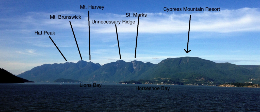
Day 1: The trail is a point-to-point, so we would drive both cars to Porteau Cove, and drop one car off, and then pile into one car to drive to Cypress Mountain Parking Lot. Best to park at the lot closest to the ski lodge if possible. We begin the hike up to St. Marks Summit for around 5.5 km, and once at the peak, definitely worth it to take a super short detour to see the views of the ocean! Continue along the trail towards the two peaks of Mount Unnecessary, and then to The Lions. (If we would like, we can hike up the West Lion for some insanely cool views, and to check that additional peak off the bucket list!). At this point we will probably want to take a break, eat, and enjoy the views. Once we are ready to continue, we will hike towards and up James peak, and continue towards and summit David peak. After traversing down David peak we will reach Magnesia Meadows. This is said to be a beautiful place to camp, so we could set up camp, eat dinner, and enjoy the evening.
Day 2: Depending how early we start the day, and how much energy we have, we can choose to summit Brunswick Mountain. There is a well marked junction that will indicate going up to Brunswick, or continuing along the trail to head into Lions Bay. (I hiked Brunswick mountain last year, and it is STUNNING. It’s the highest peak in the lower mainland area, and the views are insane — I would say definitely worth it to add, although it IS a very steep incline, and would add exhaustion to the trip for sure). After Brunswick, we hike back along the Howe Sound Crest trail along Hat Pass. We will pass by Brunswick Lake Hut, and will pass a nice creek and waterfall to refill on water if needed. We can either camp at Brunswick Lake, OR continue for another few kilometers to Deeks Lake. We could also camp here for the night and enjoy a swim (might be refreshing but definitely freezing cold in May).
Day 3: Today will be a long descent, with continue decreasing elevation until we reach the parking lot in Porteau Cove. The final 2km is along a logging road that leads to the parking lot. From here we will have to either pile everyone into a 7 seater car, OR take a few people in one vehicle back to Cypress mountain, pick up the second vehicle and drive back to Porteau Cove to get the second car and rest of the crew.